
Beginning at the start of last week, a cluster of wildfires have roared across the Texas Panhandle, putting communities and homesteads in harm’s way. The weather crisis has prompted residents to evacuate their homes, while also making travel dangerous for motorists, including professional truck drivers.
Earlier last week, Texas officials temporarily shut down the state’s Highway 136 between Borger and Amarillo, but reopened a day later. Interstate 40 near Amarillo has remained open during the wildfire breakout, but authorities have cautioned against motorists from using the roadway as rampant smoke deteriorates visibility.
On Thursday, state officials estimated that the series of wildfires in the Panhandle region engulfed more than one million acres of land, crossing into neighboring Oklahoma. At this size, the large blanket of destructive open flame is larger than Rhode Island, rendering Texas’ largest wildfire in recorded history.
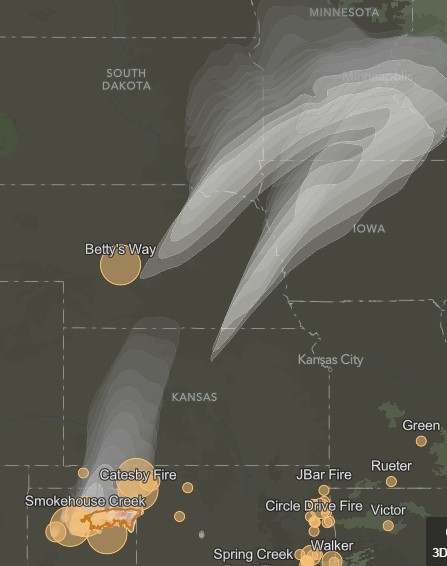
As the visual below illustrates, several fires peppered the region throughout last week. The model also forecasted smoke from the fires dispersing northward through the Great Plains as far as Wisconsin.
One wildfire has been particularly concerning. Dubbed as Smokehouse Creek, the fire’s size alone surpassed the one-million-acre mark on Thursday. Smokehouse Creek broke out Monday afternoon in Texas’ Hutchinson County and has since infiltrated into parts of Oklahoma.
On Thursday, the Texas A&M Forest Service reported only three percent of the Smokehouse Creek fire was contained. At this time, the fire was already larger than the East Amarillo Complex fire in 2006, which scorched 906,000 acres of land.
On Wednesday, Texas Governor Greg Abbott issued a disaster declaration for 60 countries in the area. The emergency measure prompted the state to deploy more resources and firefighter personnel to subdue the blaze. Other emergency responders have been tapped to support those working on the ground as well.
The chaos has been a byproduct of an uncommon string of weather conditions that flummoxed the Texas Panhandle. Warm temperatures and screaming winds initially ushered the fires through the region. This was proceeded by a cold front that pushed them even more.
The National Weather Service station in Lubbock said early Thursday that light snow began to cover the region, with temperatures dipping below freezing. Despite the cold precipitation, the fire’s strength was not perturbed. Rather, a bizarre sight unfolded—smoke mixing in with the overcast sky looming over charred plants, trees, and pastures. However, the colder temperatures do make for easier conditions for firefighters on the ground working to prevent the fires from intensifying and spreading.
The latest
As of this morning, officials with the Texas A&M Forest Service report that 15 percent of the Smokehouse Creek fire has been contained. This is a modest improvement from last week, however this large blaze, along with others, continues to run amok across the region.
Forecasters are expecting cooler temperatures and subdued winds today and tomorrow, which will provide frontline firefighters with better conditions to contain further spread. However, according to state officials via CNN, the series of Texas Panhandle fires have already burned as many as 500 homes and businesses.
Aside from Smokehouse Creek, five other fires remain active as of March 4.
- Roughneck, Hutchinson County: 300 acres, 25 percent contained
- 687 Reamer, Hutchinson County: 2,000 acres, 10 percent contained
- Windy Deuce, Moore County: 144,206 acres, 55 percent contained
- Magenta, Oldham County: 3,297 acres, 85 percent contained
- Grape Vine Creek, Gray County: 34,882 acres, 60 percent contained
Motorists, including truck drivers, should avoid traveling through the area. In addition to the many roadways and highways across the Panhandle, drivers should keep away from Interstate 40, Interstate 27, and Texas State Highway 136.
However, if traveling through the area, drivers must head safety advisories from local and state officials. Navigation platform Google Maps also provides frequently-updated information on the fires and the extent of their scope.
More blogs similar to this:

Recent Comments